Rogers speaks with InDro CEO Philip Reece

Rogers speaks with InDro CEO Philip Reece

By Scott Simmie, InDro Robotics

Rogers Communications, as you likely are aware, is a leading Canadian telecommunications and media company. Many of us watch television, cruise the internet, text and make phone calls using Rogers systems.

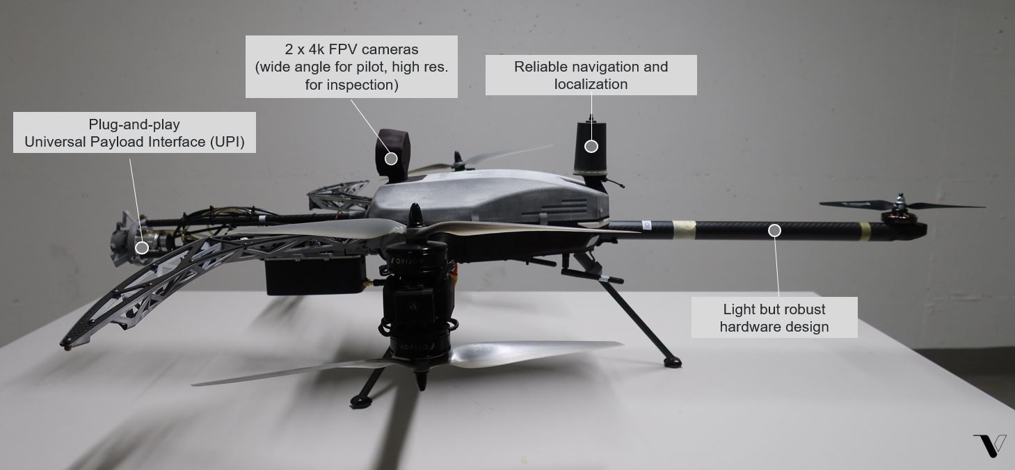
It’s also a leader in the world of 5G networks, which bring a quantum leap in wireless data transmission bandwidth. You can pump a lot of data via 5G, which opens up a lot of new opportunities for technologies like drones. For example, you could transmit crystal-clear 4K video with a drone over 5G. (We’ve already done it.)

What you might not be aware of is that InDro Robotics has partnered with Rogers on a number of projects involving flying drones over its 5G network, and transmitting real-time data back to the ground. InDro sees 5G as something of an inflection point in the world of drones and robots, paving the way for critical missions – even missions that are operated from hundreds or thousands of kilometres away.

A chat with Philip Reece

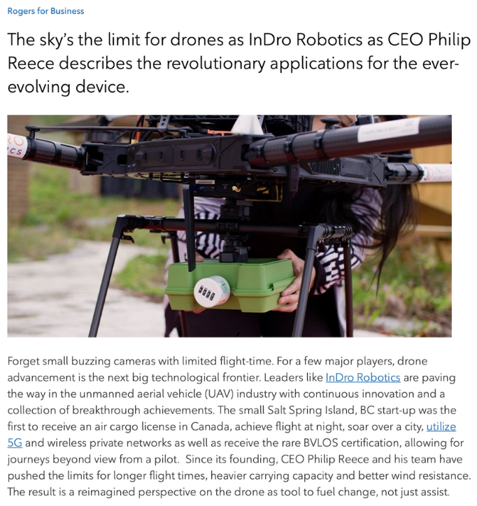
Because 5G and drones are going to be a big deal, Rogers had one of the writers from its business blog get in touch with InDro CEO Philip Reece. Specifically, they wanted to ask Philip to describe three cutting-edge uses of drone technology.

That’s a good question. And Philip was ready with some answers, which now appear on the Rogers For Business blog. Here’s a screen grab from the article:

Rogers 5G

The three examples…

It’s a good thing Philip (pictured here) was asked for only three examples, because 5G opens the door to a lot of new innovative and positive uses of drones. (InDro, if you weren’t aware, has always been interested in putting drones and robots to work doing good things.)

We don’t want to give away too much from that Rogers blog, but we will flag these three cutting-edge use-cases that Philip explores in greater detail:

  • Delivering urgent medical aid
  • Flying from public to private networks
  • Capturing critical data for First Responders

In each of the above examples, 5G plays a role in tremendously expanding the capabilities of drones. With First Responders, for example, a drone could be remotely operated over an incident by an InDro pilot – providing Responders with instant situational awareness, allowing them to focus on the task at hand instead of flying drones.

Philip Reece

Check it out…

There’s much more, of course, and Rogers captured it very well. It’s a really worthwhile read, and you can find it right here.

YOW drone detection program reveals surprising data during final days of Ottawa protests

YOW drone detection program reveals surprising data during final days of Ottawa protests

By Scott Simmie, InDro Robotics


Scores of drone flights took place in restricted airspace – what you might think of as a ‘No-Fly Zone’ – over Parliament Hill in Ottawa during the police operation to clear anti-vaccine mandate protests in February of 2022. While some of those flights were carried out by law enforcement, most flights were illegal and in violation of Transport Canada regulations.  

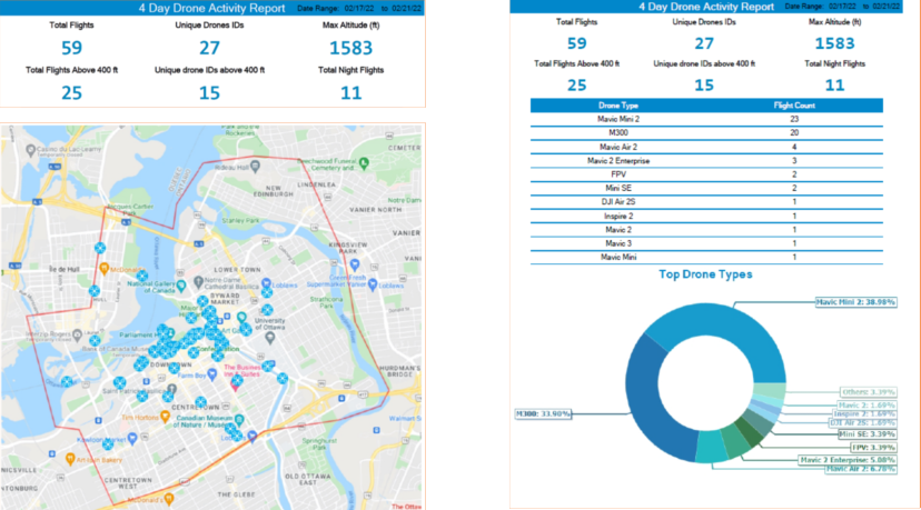
Data collected by the Ottawa International Airport Authority’s (YOW) Drone Detection Pilot Project reveals an incredible spike in flights – a total of 59 – during the days when police were actively clearing protestors from the site. 

“In an average month, you’d probably see half a dozen flights (in that same area),” says Michael Beaudette, Ottawa International Airport’s Vice President for Security, Emergency Management and Customer Transportation.  

A total of 27 different drones carried out those 59 flights over a period of four days. Of those, 25 flights exceeded 400’ above ground level (Transport Canada’s limit, except in special circumstances), with some flying more than 1500’ AGL. Eleven flights took place during hours of darkness at night – though that’s not a violation of regulations providing the drone is using lights that allow the pilot to maintain Visual Line of Sight and orientation.  

While a number of those flights were likely curious hobbyists either ignorant of or willfully ignoring regulations, it’s believed at least some were likely piloted by protestors or supporters seeking to gain intelligence of police movements. 

“The majority of those drones were not police or First Responder drones,” says Beaudette. “Some of them could have been looky-loos – just trying to see – or it could have been people wanting to know where the police were forming up.” 

Drone Detection

Drone flights, with identifying data redacted, via YOW 


Restricted airspace


The airspace above Parliament Hill (as well as 24 Sussex Drive and Rideau Hall) is restricted to all aircraft – crewed and uncrewed – unless special authorization is obtained. In terms of drones, only law enforcement or other First Responders would have legal permission to fly except in special circumstances. 

The data was obtained by Ottawa International Airport as part of a broader pilot project aimed at understanding drone traffic in proximity of the airport and developing protocols for aviation safety in the drone era. InDro Robotics is one of the partners in this project, providing key technology used in drone detection. Transport Canada regulations prohibit the operation of small RPAS within 5.6 kilometres of airports and 1.9 kilometres from helipads, except for pilots holding an advanced certification. Airspace permission is also required. (Drones weighing less than 250 grams are a different case, and we’ll touch on that shortly.)

How the drones were detected 


The airport uses two different types of technology for drone detection. The first is a micro-Doppler Radar in conjunction with an automated camera. The system, called Obsidian, comes from the British firm QinetiQ. Its high frequency (9-12 GHz) radar can detect the spinning of propellers on a drone anywhere within a two-kilometre range of the airport. Once detected, a camera automatically zeros in on the drone.  

You can get a good sense of how the system works via this QinetiQ video: 

The second system has been supplied for the trials free of charge by InDro Robotics. It’s capable of capturing data from drones manufactured by DJI, which account for approximately 75 per cent of all consumer drones.  

“Our system electronically ‘interrogates’ each device within its range,” explains InDro CEO Philip Reece. “We can triangulate the drone’s position – and on many models we’re able to also detect the type and serial number of the drone, its takeoff point, flight path, current GPS position and altitude. In addition, we can see where the pilot associated with that drone is located. With this data, YOW can quickly determine whether or not a given drone poses a threat to civil aviation.”

The system was intended to pick up any flights within a 15-kilometre radius of YOW. In practice, however, its range has been far greater. 

“When we turned it on, we realized our expectations were far exceeded,” says YOW’s Michael Beaudette. “We were getting hits 40 kilometres plus. It’s really done the heavy lifting for the drone detection project. You can identify where the pilot is, where the drone is, and where they are in real time within 15 or 20 seconds.” 

Data collected during the police operation to clear the protest reveals the bulk of the flights were carried out by DJI Mini 2 drones – very small machines that weigh just under 250 grams and which do not require a Transport Canada Remotely Piloted Aircraft System (RPAS) Certificate to operate. Microdrones like these are not prohibited from operation near airports or in controlled airspace if operated safely, but cannot gain access to the restricted airspace near Parliament without prior permission.

Drone Detection

A controversial catalyst


So. What started this project? 

The 2018 Gatwick Airport drone incident prompted many airports to take a closer look at the potential threat posed by drones. About 1000 flights were cancelled between December 19 and 21 following reports of two drones being sighted near the runway. Some 140,000 passengers were affected, with a huge economic impact. 

The incident remains controversial, because there was never any clear physical evidence that drones had indeed posed a threat. Two people were wrongfully charged, released, and later received a settlement. 

What cannot be denied, however, is that the highly disruptive incident was a massive wake-up call to airports worldwide. With an ever-growing number of drones in the air, the question of drone detection and potential mitigation became a pressing topic. If a drone detection system had been in place at Gatwick back then, it would have had concrete data as to whether there was truly a drone threat or not. 

A Blue Ribbon Task Force was launched by the Association for Uncrewed Vehicle Systems International (AUVSI) in conjunction with regulators and airport representatives. YOW President and CEO Mark Laroche was a member of the Task Force along with representatives of the Federal Aviation Administration (FAA) and NAV Canada. (Its final report can be found here.) 

Gatwick, then, was the catalyst that prompted YOW to start taking a very deep look at the issue. 

Below: Gatwick Airport. Image by Mike McBey via Wikimedia Commons

Gatwick Airport

“We wanted to be able to help shape a national drone response protocol for airports, so that we didn’t run into a situation like Gatwick, where we would have to shut down,” says Beaudette. “We didn’t even know if it’s a problem. We had to get some baseline data, some situational awareness.  So we (decided to) focus on drone detection…to identify if it was even a threat.” 

DJI, to its credit, has geofencing software that prevents its products from taking off in the immediate vicinity of major airports unless the pilot confirms on the app they have permission to do so. And while that’s useful, the geofencing is highly localized and cannot always prevent a pilot from putting a drone into the takeoff or landing path of an aircraft. 

“What causes us concern is when they’re in the flight path,” says Beaudette. 

In the fall of 2019, YOW began its pilot project. A news release made the project public in June of 2021, quoting Michael Beaudette as saying: “As an airport operator, we felt it was vitally important that we test systems to detect drones operating on flight paths, near the airport and in other restricted zones to help ensure the safety of air crews and passengers.” 

Surprising data

With the InDro and QinetiQ systems up and running, the data started coming in. It was something of a shock. 

“This opened our eyes,” says Beaudette. “We had no idea of the drone activity that was taking place.” 

There were a lot of drone flights taking place close to YOW.  

“In March of 2021, our program detected and reported on 101 drone flights within that 5.6-kilometre radius,” said CEO Mark Laroche in a news release. “April’s numbers were even higher at 167. A number of these were flown during hours of darkness and some exceeding altitudes of 1,600 feet.” 

Every month, YOW crunches the data into a comprehensive report sent to Transport Canada, NAV Canada, InDro Robotics and other stakeholders. The report from May of 2021 reveals a steep increase in the number of flights.  

Drone detection

The rapid increase was due to warmer weather and the increasing popularity of sub-250 gram drones, which are both more affordable and do not require an RPAS Certificate or registration. Here’s a breakdown of the top 30 drone models detected within a 15-kilometre radius during that same month: 

Drone Detection

The monthly report from this period states: “Detecting and identifying ‘drones of concern’ operating in the vicinity of the Ottawa Airport remains one of our primary objectives. This month, there were 19 such drones of concern within the YOW 5.6 km zone. These include drones that flew during hours of darkness, or were over 250 grams and flew over 400 ft. Of these 19 flights, there were 11 unique Drone IDs.” 

Because the system can capture drones from even farther afield, other interesting data has emerged during the course of the pilot project. 

“We started tracking other locations – Parliament Hill, Gatineau Airport,” says Beaudette. “And we were very surprised to see drones flying at all hours of the day and night and at high altitudes.” 

These weren’t just hobby flights. Unusual activity was detected around certain embassies in Ottawa, with the same drones making repeated trips. There were drones flying close to the CHEO and Civic hospital Helipads used by helicopters with the air ambulance service Ornge. There were drones apparently peering into high-rise windows, Peeping-Tom style, and others that appeared to be involved with offering intelligence to people carrying out Break & Enters. (Beaudette says police were notified in some of these instances.) 

As part of the Pilot Project, YOW worked with its partners – including NAV Canada, Transport Canada and InDro Robotics – for some real-world exercises. One such test involved determining the accuracy of the detection system. A drone was flown (with all appropriate permissions) from the E.Y. Centre, a massive exhibition/convention facility very close to the airport. When the data captured by the detection system was overlaid with the actual flight log, they were identical. Not only that, but the YOW data precisely identified the location of the pilot. 

“We could actually tell which stall in the parking lot (the pilot was standing in),” says Beaudette. 

Mitigation


Detection is one thing, but drone mitigation is quite something else. There are systems capable of jamming the Command and Control signal between the drone and the controller (including systems from Bravo Zulu Secure part of the InDro group of companies. Here’s a quick overview of how these systems work. 

But such systems are not in cards for YOW or other airports in Canada. Quite simply, Transport Canada and Industry Canada (which regulates radio spectrum frequencies) prohibit them in this country except in extraordinary circumstances. 

“First and foremost, a drone – like any other airplane – is considered an aircraft,” says Beaudette. “And so Transport Canada has restrictions: Nobody has the authority to interfere with the flight of that aircraft. So you won’t see airports with jammers or other kinetic solutions to that unless they have the proper authority.” 

Plus, he emphasizes, the Drone Detection Pilot Project is focused on drone detection. It’s a data-gathering exercise to help formulate protocols, provide useful information for regulators, and alert airport authorities immediately if a drone poses a threat to a flight path. YOW is not the drone police; its primary interest is in ensuring the safety of aircraft using the facility.  

“If we can detect something, we may be able to mitigate it by rerouting aircraft, delaying aircraft, or we can locate the pilot,” says Beaudette. 

Thankfully, despite many flights violating the 5.6 kilometre radius, YOW has not encountered a drone that posed a serious threat since the program began. Should that occur, it does have protocols in place to ensure civil aviation safety. Plus, of course, Transport Canada has the option of imposing heavy fines on pilots who put aircraft at risk or are flying without a Remotely Piloted Aircraft Certificate. And with the detection system in place, locating an offending pilot would not be difficult. 

Know the regs

Ultimately, the biggest piece of the puzzle is around education. Some pilots simply don’t know the rules and unwittingly violate them – an excuse that won’t help them much if facing a fine. YOW has found, for example, that pilots often fly from nearby neighborhoods or golf courses without realizing they’re impinging on that 5.6 kilometre zone.  

There’s also the issue of confusion around piloting sub-250 gram drones. Because they do not require an RPAS certificate or registration, many believe the rules somehow don’t apply to them. Yet the over-arching meaning of the regulations is clear: They must not be flown in an unsafe manner. And that includes near airports. 

“We actually had a case where we found a drone that crash-landed inside the (airport) fence,” says Beaudette. 

“We’re still the proud owners of that drone.” 

InDro’s take

Several members of the InDro Robotics team – including our CEO – have expertise as private and commercial pilots. As a result, we have perhaps a heightened awareness of the potential risk drones can cause if they’re in the wrong place at the wrong time. Drone detection at airports and other sensitive facilities is critical, and the deep data collected by YOW reflects that.

We’re proud to be part of the YOW Drone Detection Pilot Project and look forward to assisting others with drone detection and even mitigation, where appropriate. If you’re interested in exploring such a system, we’d be happy to help.

New drone instruction portal lets new pilots go ‘FLYY’

New drone instruction portal lets new pilots go ‘FLYY’

By Scott Simmie

Thinking about earning your Basic or Advanced RPAS Certificate but don’t know where to start? Want some tools to help prep for your Transport Canada required Flight Review? Looking for some answers in a friendly, supportive community of drone pilots?

Look no further. InDro Robotics is very pleased to announce FLYY, an online drone learning portal with an incredible amount of offerings and features. What’s more, the person behind this major initiative is none other than InDro’s Kate Klassen, a highly respected professional and instructor in both the traditional aviation world as well as the drone sector.

FLYY

If seeing that image of Kate in a studio rings a bell, that’s understandable: Kate developed and fronted one of the most successful online drone courses in Canada. Now, she’s taken all of that experience and expertise and put it into a comprehensive learning platform with multiple course offerings. There’s something for everyone, ranging from the absolute beginner to seasoned pros looking to up their game. There’s even a brand new and supportive Forum, where Kate and others can weigh in with helpful tips or answer questions. No trolls here; just a collaborative and growing community eager to learn and share.

We’re excited. And so is Kate.

“I’ve constructed the FLYY courses and guides to ensure success for those seeking to become Basic or Advanced RPAS pilots,” she says. “It was so fun to get back into content creation mode and then into the studio to record this training – no promises my jokes have gotten any better though!”

Special FLYY launch discount


We could go on and on. But we also issued a news release about this – so no point reinventing the rotor! We’ll paste that release in a second so you can see all the details, but wanted to point out that FLYY is offering 15% off until March 1. So if you’re in Canada and want to be ready for spring piloting, hop on over to the FLYY website and take a look at some of the course offerings.

Believe us, there’s something for everyone, including helpful FLYY Guides and even Flight Reviews. Once you’ve made your selection, apply the code FLYY15 at checkout.

Drone Training

The news release


Okay, for those of you looking for even more information, you can see our news release below, or download it here.

Happy piloting…and congratulations, Kate Klassen. Having been through the site, we can tell you she has done an absolutely amazing job with these comprehensive, Transport Canada compliant course offerings.

FLYY
Drone Training
First Responders find drones invaluable tools

First Responders find drones invaluable tools

By Scott Simmie

It’s no secret that drones have become an essential tool for many First Responders.

Emergency services frequently use these devices to obtain situational awareness – also known as “The Big Picture.” Police departments deploy them to search for missing people, locate suspects, monitor protests and collect images following serious collisions in order to clear the scene more quickly. Fire departments use them to monitor fires, detect hot spots, hazardous spills and more. And paramedics? Well, they’re using them too.

In fact, paramedics in Ontario used a drone – as first reported in this story – to assist during a Search and Rescue operation on a cold winter’s night early in 2022. Specifically, it was members of the Hastings Quinte Paramedic Services based in Belleville, Ontario.

Not surprisingly, that got us interested. And so we contacted Mike Slatter, Deputy Chief of Quality and Development, to find out more. As it turns out, we’d seen Deputy Chief Slatter make a presentation about drones back in 2019 in Ottawa at the annual national convention of Unmanned Systems Canada (now the Aerial Evolution Association of Canada).

We were really eager to learn more about how his team came to use drones. And, more specifically, how it uses them in some of its day-to-day operations. We found what Mike Slatter had to say fascinating – and believe you will, as well. FYI, that’s Deputy Chief Slatter in the image below, bringing in a drone for landing.

First Responder Drones

Paramedics do more than you might realize…


We started this off with a simple question. What do paramedics do?

Deputy Chief Slatter explained that in the case of Hastings Quinte Paramedic Services, there’s much more to the job than car crashes or calls to homes and businesses. Its rural catchment area means hunting accidents or injuries on farms crop up. The paramedics also assist local fire departments, sometimes offering medical assistance to firefighters who have just emerged from the heat and smoke of an active fire.

What’s more, Canadian Forces Base Trenton is nearby, and the service responds to calls there. Slatter’s team has also worked with members of the CFB Trenton Search and Rescue team, and sometimes receives occasional calls from CFB Mountain View, an airfield which also has a parachute jumping site.

That’s not all. Come summer, the area fills up with vacationers. There are boating accidents, drownings, injuries on the beach and more. So the workload involves a lot more than car accidents.

Drones enter the picture


With the help of a federal program, the paramedic service got into the drone world in 2018. Members of the service first did online training through InDro Robotics, followed by in-person flight instruction with InDro staff.

“I was fully impressed,” says Slatter. “Philip’s team was very professional; I thought it was very reassuring that Philip is so connected on the cutting edge of what’s going on with drones and safety. The experience was invaluable.”

Since then, the Service has deployed its DJI Matrice 210 and Mavic Pro Enterprise on a variety of missions, including Search and Rescue, house fires (using FLIR thermal imaging to detect hotspots), and even at a high school lockdown for situational awareness.

But not every drone mission is a dramatic, slam-dunk with a high-profile rescue. The real utility, says Slatter, is the ability to provide First Responders with that ‘big picture’ situational awareness.

“It gives you such a different perspective as to what’s going on,” he says. “The field of vision during the day is just amazing, and the camera technology is quite useful for zooming in and looking at things more closely to determine what’s happening.”

Let’s zoom in ourselves, and take a closer look at two recent incidents involving Hastings Quinte Paramedic Services.

First Responder Drones

Friday, January 28


Someone calls 9-1-1. They think they hear someone out on the ice at the Bay of Quinte calling for help.

It was still daytime, but the ice had a thick covering of snow – which would have made searching on foot a slow and laborious task. There was also a lot of ground to potentially cover, dotted with the occasional ice fishing hut. To give you a sense of scale, most of those huts were at least two kilometres from the shore.

“The Fire Department was there with their iceboat and team,” says Slatter. “The area we were looking at probably had a radius of five kilometres.”

With excellent visibility and a drone remote control monitor designed for high visibility even on sunny days, Slatter and his colleagues could monitor a live high-resolution video feed from the drone. With a background of snow and ice, it was relatively easy to scan fairly large areas as the drone flew overhead.

Scenarios like this make the drone what’s often termed a “force multiplier” – meaning the information it was gathering was greater than a single person could have acquired on their own. It also meant the Fire Department could pull its team back from the ice to wait on shore. There was no point in slogging on foot for kilometres when the drone could do the job.

Did it find someone? No. But it also revealed that no one appeared to be in distress in the reported area. That information was valuable for all the First Responders: Resources would not be expended where they were not required.

“Essentially nobody had to go out on the ice and it saved a lot of time – taking it from being an operation that would have taken several hours to about an hour or an hour and half,” says Slatter. “We were also able to cover areas along the shore that would have been difficult to get to, as well.”

Monday, January 31


Another emergency call, this time as dusk was approaching. A person who had been searching for a runaway dog had become lost in the Sandbanks Provincial Park. The Ontario Provincial Police also received the call, and asked the paramedics if they could bring their drone. The OPP, as it turns out, had limited resources due to the protests in Ottawa. Because of that, an OPP helicopter that might normally have been put to use was unavailable.

The OPP dispatched search teams on an All-Terrain Vehicle, and suggested a location where the drone might be most helpful. The paramedics launched their Matrice into the dark sky.

The drone’s FLIR thermal sensor is designed to detect differing levels of heat on the ground: The brighter the image, the warmer the object.

Thermal cameras are incredibly useful for finding missing persons at night, when the ground is cooler than during the daytime. A human being will display a relatively bright heat signature that contrasts the ground. In this case, you can see a paramedic ATV that seats two, also known as a Side-by-Side. Slatter scanned the area, searching for a bright spot that might indicate a person.

Emergency Response Drones

The drone was flown back for a battery swap, and then it was returned to the air. An OPP K9 unit had discovered some tracks that matched the description of the boots of the missing person. They were fresh. The OPP and paramedics, each in their own ATVs, began following those tracks toward a beach area. Slatterly returned the drone to the sky and began following the searchers while monitoring a much wider area from above.

“There are lakes on two sides of the area we were in,” says Slatter. “Because there are sand dunes, with the ice buildup there’s a lot of crevices along the shoreline. So the main concern was that the person had fallen or laid down due to being tired. By being up in the sky we could see a greater view than just a single person on the ground.”

Drone Detection

As the second set of batteries became exhausted and paramedics were returning the drone, word came in: The missing person had been located elsewhere.

‘Hey’ – you might think. ‘The drone didn’t find them.’ No, it didn’t – because they weren’t in the search area. But that is *precisely* the point in this case. The drone provided accurate intelligence that the missing person was not in a location being searched.

And that is absolutely valuable information that assisted First Responders.


“(It was) Very useful,” says Slatter. “We were able to cover a larger area and  eliminate areas where we felt the person wasn’t.”

And so, in these recent two examples – both occuring within a week – paramedics dispatched drones. These cases might not grab headlines in the way a dramatic rescue might, but the drone provided valuable data. What’s more, these examples are highly illustrative of just how much a part of the daily First Responder toolkit drones are becoming.


What’s next?


Drones are clearly now part of the workflow, when required. There’s also no question that the technology continues to advance. InDro Robotics, for example, has conducted numerous trials using drones to transport Automated External Defibrillators, transporting them to the scene of a simulated cardiac arrest. Drones tend to get there significantly faster than a paramedic vehicle. InDro has also delivered critical pharmaceutical supplies, such as an EpiPen (used to treat severe allergic reactions that can prove fatal) or Narcan (Naloxone HCI nasal spray), used for opioid overdoses.

You can see an example of this kind of work here:

And the future?


With successful trials of AED deliveries and pharmaceuticals delivered Beyond Visual Line of Sight, it’s not a huge leap to envision a future where such flights are routine. Where, for example, a 9-1-1 call for cardiac arrest might simultaneously dispatch an autonomous or remotely piloted drone to the site of the call. Or where an Epipen reaches someone in respiratory distress within minutes.

It’s a future Deputy Chief Mike Slatter believes could well be on the horizon as an important tool for First Responders.

“I think we are definitely on the cusp of that happening,” he says – adding that the Hastings Quinte Paramedic Services has purchased its own small AED for its drone.

“I think the potential for a small First Aid Kit or Narcan (delivered by drone), especially in the rural areas like we have here, definitely would have benefits… I think getting that device to a person even a couple of minutes ahead of a responding ambulance or First Responder could make a difference for a person.”

Slatter also has some final words about InDro’s training.

“It was very reassuring that (CEO) Philip (Reece) is so connected on the cutting edge of what’s going on with drones and safety,” he says. “You see a lot of different companies out there advertising drone training. And it calls into question: What is the standard for a training service? And I think that’s where InDro has set the benchmark. Our program really has credibility because of the training that we did with InDro.”

InDro’s Take


InDro Robotics has both deep respect for and a proud tradition of working with First Responders. We’ve helped train and outfit paramedics, RCMP and others across Canada, building solid relationships along the way. Drones have become an indispensable tool for Emergency Services, aiding in rapid decision-making, keeping First Responders out of harm’s way – and even saving lives. With advances in drone technology and ground robotics, we’re confident these devices will become an even more essential part of their toolkit in the future.

If you are a First Responder looking to gain drone skills or upgrade the skills of your team, there are a couple of InDro options. You can gain the knowledge required for your Basic or Advanced Remotely Piloted Aircraft Certificate online through an InDro course here. We also provide in-person instruction, anywhere in the world. Please get in touch.

CONTACT

INDRO ROBOTICS
305, 31 Bastion Square,
Victoria, BC, V8W 1J1

P: 1-844-GOINDRO
(1-844-464-6376)

E: Info@InDroRobotics.com

copyright 2021 © InDro Robotics all rights reserved

A Q&A with Volatus Aerospace CEO Glen Lynch

A Q&A with Volatus Aerospace CEO Glen Lynch

By Scott Simmie, InDro Robotics

If you’re in Canada, odds are you’ve heard of Volatus Aerospace by now.

And that’s not surprising. The company has grown, and quickly, through a number of strategic mergers and acquisitions. As a result, it’s now offering a wide variety of drone services across multiple sectors – and in several countries.

That growth, and the selection of companies, have been highly strategic.

The companies Volatus has acquired are now part of The Volatus Aerospace Group. Collectively, they offer a broad swath of specialized drone services, ranging from industrial inspections, digital twins and heavy-lift capacity through to sales and one-off aerial photography and videography services. Plus, parent company Volatus is also in the game. It will soon be operating a manufacturing facility at the Lake Simcoe Regional Airport, producing two different UAVs. And it has ambitious plans in the heavy-lift drone cargo sector.

The company’s CEO is Glen Lynch, who enjoyed a long and successful career in the traditional aerospace world prior to entering the UAV space. Here’s a look at the firm’s overall offerings, taken from its website:

Drone Services

That’s a pretty ambitious palette. But Volatus has been very targeted in its acquisitions. It has focused on companies that were already specialists in their own respective niches. Pull them together under a single umbrella and you’ve got the makings of synergy – where the whole is greater than the sum of its parts.

You’ve also got the groundwork for “One-stop shopping” when it comes to drone service provision, and even the purchase of certain drones. It’s the only company in Canada we’re aware of that has taken this approach at scale. As a result, Volatus has quickly become a household name, at least in those Canadian households familiar with the UAV scene.

Before we get to our interview with Volatus CEO Glen Lynch, let’s find out more.

Drone Training

What’s under the hood?


Here’s a brief look at the companies within the Volatus portfolio.

Canadian UAV Services. The Ontario-based company has been in business for seven years (as of early 2022) and offers a number of services. They include: Inspection, surveys, GIS, aggregate mining data capture and more.

Connexicore. The Philadephia-based company offers a wide range of professional drone services. Connexicore operates somewhat like a hub, connecting jobs with its North American network of 1,000 freelance pilots. Those pilots fly with certification under the FAA’s Part 107.

M3 Drone Services. Based in Manitoba, M3 provides UAV services across a broad number of sectors, as well as training. The company offers its services Canada-wide.

OmniView Tech. This firm is the largest drone repair centre in Canada. The company distributes DJI products to retailers and sells them directly, as well as other drones and specialized sensors.

Skygate Videography. Located in Prince Edward Island, Skygate offers training, drone videography and inspection services.

UAViation Aerial Solutions. With offices in Vancouver and Edmonton, UAViation provides a range of aerial services, including photography, photogrammetry, LiDAR etc. Founded in 2015, its website says the firm has carried out some 4,000 flights, logging 1000+ flying hours in more than 500 locations.

MVT Geo-Solutions Inc. Volatus has announced an agreement to acquire the Quebec-based firm. According to a news release, its “services include data collection, processing, and analysis to a variety of industries including civil engineering, transport, hydrography, natural resource management, forestry, and public safety.”

And, finally…

Partner Jet/Volatus Aviation. This charter passenger jet and aircraft management firm is located at Pearson International Airport. It was the initial starting point for what has become the Volatus Aerospace Group. The company will also play a role in future Volatus plans, such as heavy lift cargo drones, some of which would require aircraft runways. The company owns and operates the Citation X jet seen below.

Volatus

Glen Lynch, CEO

With all of that background, we’ll now hop into our Q&A with Glen Lynch, Volatus CEO.

Q: What’s the elevator pitch for Volatus?

A: To understand the company, you need to understand where we came from. It’s a company that kind of grew from the aviation industry. When we looked at the drone market, we realized there was an exploding opportunity – basically an industry that was rocketing out of a nascent phase – but there were no operators of any real scale. It was basically an industry that was being served by small businesses, with the exception of companies like InDro. Very capable small business, but small business nonetheless. That’s what we saw as being the opportunity.

So what we did was, basically accumulated a number of businesses through M&A (merger and acquisition) activities that had two characteristics: A strategic location and a complementary capability. And then we consolidated them using a roll-up strategy to create what’s now one of the larger fully-integrated drone services and drone technology companies. And that’s basically who we are. We cover now all of Canada, all of the United States, and we’re starting to have some penetration now in Latin America – we have an office in Bogota, an office in Lima Peru, and business activities as far south as Chile.

Q: The Volatus Aerospace Group holds a number of companies that are all specialists in specific areas. Could you provide more details about how you selected these companies?

A: Once you identify the first company – the principle of that company usually has other companies they’re interested in. So it becomes somewhat of a referral, because the relationships already exist. And the one thing that’s particularly core: When you have an M&A strategy that’s as active as ours, we need to be able to acquire companies and retain the leadership. One of the things I’m most proud of with Volatus is that we’ve retained 100 per cent of our leadership through the acquisitions – and that allows us to scale more rapidly. Well, to be able to retain leadership there has to be a cultural fit. Oftentimes, favourable referrals from people who are already fitting with the group almost becomes a natural screening process…

At the end of the day, we’re looking for good fits. And we’ve been really fortunate to find some really talented individuals that have built some really great companies and have shared the vision of Volatus and we’ve been able to entice them to join us.

Volatus

Q: A little over a year ago, Volatus wasn’t exactly a household name. Now, you’d be hard-pressed to find someone in the drone world who hasn’t heard of you. How did you scale so quickly?

A: I would say that probably it’s something I’d love to take credit for. But the reality is, we have some really talented people, people like Rob Walker, who’s a well-educated, award-winning marketing professional. And we created an umbrella branding strategy, so at the end we’re pushing a common brand. We’re very careful not to lose the brand equity in our subordinate brands but we push out a single brand proposition, I would say, throughout the marketplace. And, again, it’s really driven by the people that become part of Volatus: They become proud of the brand, they become associated with the brand, and the brand naturally grows. On top of that we’ve hired a very large business development and sales team that work right now across Canada and the United States. And actually our office in Lima Peru has three business development people in that office as well. So we’re out there. We participate in a lot of trade shows. We spend a fair amount of money in marketing, but we try to be very, very balanced in our approach to investment and general brand awareness. And we really target places that we can generate revenues today. So we keep an eye on the blue sky, we prepare for the blue sky, but we very much focus on the places that we can actually achieve revenue activities in the near term.

 Q: You and your VP both have an extensive background in traditional aviation. What advantage does that give you in the drone world?

A: Luc Massé, who’s executive Vice-President, he was one of the driving forces in what is now one of largest aircraft companies in Canada. Funny enough, he was one of my competitors for many years in that space. But there are a few things, I guess. It helps us have a very comfortable awareness of the realities of operating in a regulated environment.

When we’re collecting data, that’s one type of service. When you’re carrying something that belongs to somebody else?  That becomes a cargo service. By definition that’s a commercial air service. So there’s a whole new range of requirements there, for example economic authority as well as just operating authority. As you know, InDro was one of the first companies to do this, they have a Canadian Transportation Agency Cargo License. And right now, to the best of my knowledge – I may be missing somebody – there are only three companies in Canada that actually hold that economic authority: (InDro), Drone Delivery Canada and ourselves at Volatus Aviation, which was formerly Partner Jet. So it really helps us position for the future, having that understanding of aviation, because largely on the cargo side, we kind of know where the industry is headed. There’s a convergence there, between manned and unmanned aircraft.

Volatus

Q: Volatus is pretty diversified in the drone world. Is there a particular area you’re involved with that you’re most excited about for the future?

A: I would say our major areas of interest in 2022, other than continuing to scale our existing business..in terms of new growth areas it would perhaps be drone cargo activities. And drone cargo for Volatus means ship-to-shore, shore-to-ship, ship-to-ship, remote communities, inter-island type activities: Things that we can do either because they’re eligible under the current regulatory framewok, or actually they can build a risk profile that will allow us to get authorization to operate under special circumstances. So that’s a big area of focus for us this year, we’re putting a lot of investment – as you’ll see in the near future – in that space.

And the other one is in public safety. Drones as First Responders is becoming. a major thing; there’s literally tens of thousands of law enforcement agencies, let alone other public safety agencies like the emergency health response units,  firefighting, Search & Rescue, all of those sorts of things. So those are two big areas of focus for us in 2022.

Note: Soon after our interview, Volatus announced its intention to purchase a planned Natilus N3.8T Large Remotely Piloted Cargo Drone. The twin-engine turboprop blended-wing aircraft has a maximum gross takeoff weight of 8,618 kilograms (about 19,000 pounds) and is capable of carrying 3,855 kilograms of cargo (8,500 pounds). This machine, slated to be delivered in 2025, will obviously require traditional airport infrastructure and significant advances in Unmanned Traffic Management. There will also be some fairly high regulatory hurdles to be cleared in order to operate a vehicle of this scale.

“The recent amalgamation with Partner Jet Inc. gives us the commercial infrastructure to operate drone cargo services, and the addition of Natilus aircraft establishes the long-term direction for our aviation division,” said Lynch in this post announcing the news. Here’s the Natilus promotional video, which offers a CGI version of the planned craft:

Q: You were listed recently on the TSX (VOL). What does this listing mean for the Volatus group?

A: Getting to the public listing was one journey, but now the heavy lifting begins. If we handle ourselves correctly, it’s an opportunity to demonstrate good governance and a serious, solid, well-run corporation. So that’s up to us to deliver on that. But the second thing that it does, it gives us access to capital markets, which allows us to – especially as the company grows in value – allows us to access capital that will continue to allow us to grow through acquisitions or fund organic growth internally through ramp-up of inventory and those sorts of things. So that’s the primary objective is really to give us the mechanism to scale.

InDro’s take


Volatus has emerged quickly and appears to have significant momentum. In addition to its other operations, the company is currently setting up a large manufacturing facility at the Lake Simcoe Airport, where it will be producing two UAVS. Glen Lynch, as CEO, has both the business and traditional aviation background to guide the company as the industry moves toward the world of Advanced Air Mobility (AAM), where new types of short-range aircraft will be sharing the skies with drones. We wish the Volatus team well.