InDro Robotics delivers COVID-19 tests by drone in B.C.

InDro Robotics delivers COVID-19 tests by drone in B.C.

Throughout 2020, healthcare providers of Penelakut Island in British Columbia, Canada, were challenged with a very difficult situation. 

Due to the COVID-19 pandemic, a single ferry boat was accessible between the island and the nearest medical lab located in Chemainus on Vancouver Island, putting the timely transport of samples at risk. 

The process of getting the supplies to the lab took hours to complete, and one of the island’s three nurses had to travel with the supplies, making them unavailable to provide health services during the day.

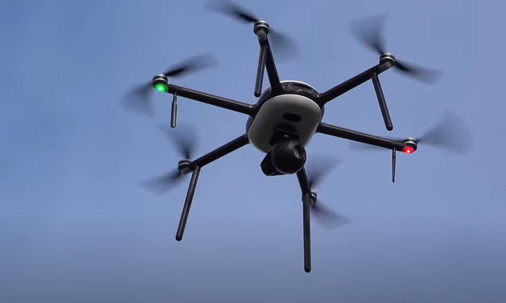
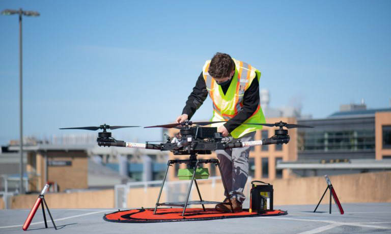
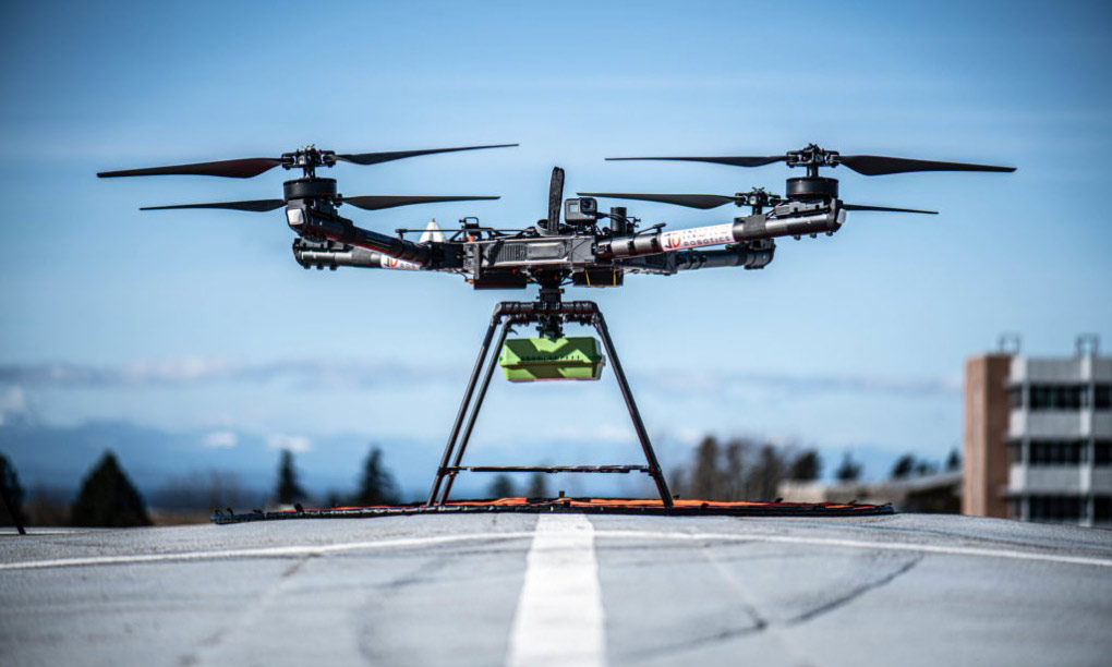
InDro Robotics was tasked by the Island to begin deploying a Unmanned Aerial Vehicles (UAVs), or drone, to expedite the transportation of COVID-19 tests,

To start evaluating this problem, the team at InDro Robotics worked alongside Penelakut Island’s residents in strategizing a plan to fly samples using specialized drones and navigation software. Penelakut Island is currently home to over 1,000 people from the Penelakut First Nations community.

While InDro Robotics had the technology to fly between both islands, connection latency became a key issue during the trials.

Often drones are equipped with satellite connectivity solutions to accommodate the real-time video streaming needed to enable Beyond Visual Line of Sight (BVLOS) operation of UAVs (Unmanned Aerial Vehicles). However, according to Philip Reece, President and CEO of InDro Robotics, satellite is hindered by as much as 7 seconds of latency, which is way too much to provide safe operations for BVLOS.

Transport Canada also requires companies to use technology features that track signal

strength during a UAV’s journey. This meant that any solution chosen by InDro Robotics would need to support such features while integrating their proprietary flight navigation software.

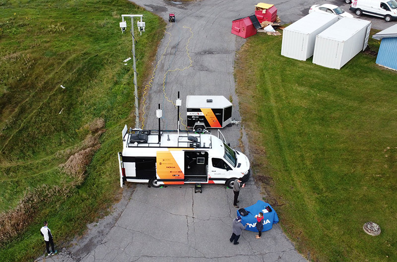
As a solution for the constant high-performance connectivity needed for its drones, InDro Robotics deployed Cradlepoint’s NetCloud Service for Mobile, with the Advanced Plan, and wireless edge routers built for in-vehicle use. NetCloud’s cellular signal monitoring and thermal mapping features would allow InDro Robotics to optimize performance and safety during the drones’ route.

Using Cradlepoint’s NetCloud API, InDro Robotics was able to pull GPS-based cellular health information into the company’s flight navigation systems.

These endpoints also leveraged LTE service, provided by Rogers, instead of satellite connectivity, which carries too much latency for the real-time video streaming necessary on these flights.

The cloud-managed cellular connectivity would ensure that the low-latency video streaming can be essential to successful drone flights, and the map-based performance analytics can still be necessary to optimize flight patterns while meeting Canadian drone regulations.

“Using an enterprise-grade router on our drones allows us to stream video well from two on-board cameras along with full command and control, which is essential as we continue to expand our UAV products and services,” said Reece.

InDro Robotics also used NetCloud’s GeoView suite of location-based features forregulatory requirements. This was used to save time and money during the project, as InDro Robotics was able to track cellular health analytics and identify “dead zones” on a heat map during several test flights in various weather conditions on various routes. This lead to evidence-based decisions about the best possible flight paths to and from the island for its UAVs.


Fortunately for residents of Penelakut Island, these LTE enabled drones can mean medical supplies and COVID-19 tests will be swiftly transported in a shorter time-frame. This also meant that local medical professionals could offer more time to serve their patients on the island.


END NOTES


InDro Robotics is a leader in drones, or  Unmanned Aerial Vehicles (UAVs), as well as the first North American company to develop beyond visual line of site (BVLOS) technology with regulatory approval for emergency and first responder missions. InDro Robotics has accumulated thousands of flight hours and has collaborated with leading agencies such as Transport Canada, Canadian Space Agency, and NASA.

InDro Robotics inspects transmission power lines on private LTE network with NYPA and Nokia

InDro Robotics inspects transmission power lines on private LTE network with NYPA and Nokia

In partnership with Nokia and the New York Power Authority (NYPA), InDro Robotics ran a highly successful demonstration with Unmanned Aerial Vehicles (UAV), or drones, that were installed with private LTE wireless technology. 


The first-of-its-kind, InDro Robotics’ drone inspection with NYPA – one of the United States’ largest state public power organizations – exhibited the ability to control onboard high definition and thermal imaging devices during inspections within close proximity of in-service transmission lines. 


InDro Robotics’ was chosen for this project due to their extensive expertise in operating UAV’s in unprecedented ways when NYPA was scouting out drones for transmission line inspection.

These test flights were also aimed at assisting the NYPA, and possibly other corporations, to safely inspect miles of transmission lines using wireless networks to convey images and data.

Within the visual line of sight and fully compliant with FAA rules and regulations, the drone flights took place in December 2020 at NYPA’s Blenheim-Gilboa Pumped Storage Power Project in Schoharie County, New York. 

 The test flights were part of the NYPA pilot program, which began when the NYPA partnered with Nokia of America Corporation to pilot private wireless LTE technology. Using Nokia’s Digital Automation Cloud platform, NYPA is hoping to build a secure and reliable network that would enhance operational and programmatic benefits. Once this network is finalized, NYPA expects to petition the Federal Aviation Administration for permission to fly drones beyond visual line of sight (BVLOS) to make their inspections of transmission lines easier.

In using the LTE wireless network system for inspections, NYPA is looking to adopt the network in other areas. This includes workforce mobility applications (voice-over LTE), 30x optimal zoom camera, deep metering services and data of customer energy consumption, Wi-Fi telephony and Push-to-Talk (PTT) applications, as well as data transport that would support NYPA energy efficiency initiatives.

InDro Robotics drives new future with Mobile Command Centre

InDro Robotics drives new future with Mobile Command Centre

The Area X.O Mobile Command Centre (MCC) is a one-of-a-kind command vehicle that was
originally established by InDro Robotics.

The project was developed through a unique collaboration between InDro Robotics, Invest
Ottawa and other Ottawa based industry partners such as Nokia, Kongsberg GeoSpatial, SmartCone Technologies, Inc., and Microsoft.

The fully equipped 5G mobile command vehicle features remotely piloted aircraft systems
(RPAS). The vehicle is also capable of deploying a secure 5G network at any time, and
anywhere. In creating this system, InDro Robotics worked closely with first responders in
ensuring the vehicle is built to support emergency workers and rural innovation by allowing
small and medium-sized enterprises to ratify more solutions in their area.
The objective of the vehicle was to create a mobile technology that can be deployed rapidly for
emergency first response, search and rescue, command and control, and smart mining and
smart agriculture.

“One vehicle that can pull together a joint command of emergency support and offer a more in-
depth situational awareness can really assist in many unexpected natural disasters,” said Philip
Reece, President and CEO of InDro Robotics.

Vehicle

The base frame of the MCC is a Mercedes Sprinter 2500. The interior of the command vehicle features a workspace for the system operators, including seating and space for monitors, which was provided by Invest Ottawa. The system uses high-performance and reliable private wireless connectivity between the vehicle and Nokia’s drones to create situational awareness of critical situations happening in close proximity.

Unmanned Ground and Aerial Vehicles
The MCC allows for drones to be automatically deployed on-site. The pilot and payload operators; stationed within the van control multiple RPAS flights, while transmitting live video and data back to the Pilots, MCC and offsite command centres. The van’s multiple screens allow for full coordination of the drone, even in the most complex areas. The van’s Kongsberg system works by scanning the skies for other aircraft, while Smartcones technology secures the ground environment.

Advanced Sensor Analytics Capability
Advanced sensors from SmartCone Technologies, Inc. were installed to increase situational awareness, including ultra-wideband positioning system, asset tracking, bird’s eye surveillance, and more. Kongsberg Geospatial IRIS UxS system uses a sequence of sensor and software technology that gives operators a real-time picture of their operational area when piloting one or more unmanned vehicles beyond visual line-of-sight (BVLOS). A Microsoft AzureStack Edge system is also deployed to enable edge analytics across secured data from RPAS footage and sensors in disconnected areas. This will enable first responders on the ground and inform central headquarters with full awareness of the situation.


LTE and 5G Radio Capabilities

The Area X.O MCC is equipped with private LTE and 5G radio systems that are enabled to
instantly deploy communication bubbles around the area of the vehicle. The 5G can be used to help first responders become more efficient in gaining situational awareness with the vehicle’s range of environmental sensors. 5G can also be deployed to provide last-time connectivity in rural areas, bringing high-speed broadband to everyone in the area.

InDro Robotics played an instrumental role in the creation of the MCC by contributing novel
RPAS technology and expertise to the fully equipped van. Once the vehicle was completed,
InDro Robotics expanded to Ottawa to capitalize on more opportunities at Area X.O., launched
by Invest Ottawa, and looked to bring more capabilities to innovators, firms, and communities
across Ontario.
Nokia and Area X.O will tour the MCC across Canada to demonstrate how the vehicle can be
used for aiding in unsafe conditions and defending public safety. Public safety organization who
are interested in demonstrating the MCC can contact InDro Robotics here.
“We were really impressed with how the partners’ technology all fit so well together to produce
an end result that has not been seen before in a mobile command unit,” said Reece.

Regulations

Regulations

Canada’s regulatory framework is shifting to support the safe integration of drones into ‘shared national airspace.’ As more and more industries, government agencies, educators, and the public launch drones of all sizes into national airspace, new legislations and significant coordination is needed to mitigate risks for manned aviators. Manned aviation includes commercial airlines, private pilots, crop dusting crews, and emergency response teams using water bombers for firefighting and helicopters deployed for search and rescue missions. 

InDro Robotics will post content here educate the public about the current and up and coming Canadian Aviation Regulations that impacts the industry. Drones are also commonly referred to as Unmanned Aerial Vehicles (UAV’s) or Remotely Piloted Aerial Systems (RPAS). Legislators are being forced to update aviation regulations to incorporate the adoption of these new technologies. InDro Robotics will keep you informed about aviation authorities and policy makers from municipal, regional, national and international agencies who are working to implement, promote and then enforce a safe – yet supportive –  regulatory framework to required for drone industry growth. 

Screen Shot 2018-08-02 at 4.33.58 PM.png

Regulations

Transport Canada defines the aviation regulations that support the safe use of drones and other remotely-piloted vehicles. They work with other authorities (NAV Canada, airport associations, etc.) to guide the safe integration of drones into Canadian airspaces. InDro Robotics works as a technical advisor to Transport Canada and other government agencies by providing policy input and training various Transport Canada Inspectors on the use and operation of drones.

 
IMG_2555.JPG
 

Transport Canada Minister Honourable Marc Garneau announced much-awaited new regulations today in Ottawa for the rapidly-growing Remotely Piloted Aircraft Systems (RPAS) industry. Highlights include a mandatory drone registration system and knowledge tests that all pilots will have to take to earn a permit/certificates to fly drones in the ‘small RPAS’ weight category (between 250g and 25 kg). Learn more about the regulations announced in Canada Gazette II, the Transport Canada testing portal and details of the Basic Operations and the Advance Operations categories through our InDro response and press release, here.

 
InDro_and_Transport_Canada_Team_.JPG

December 2018 – InDro Robotics was one of only four companies approved by Transport Canada in 2018 to conduct Beyond Visual Line of Sight (BVLOS) Trials. InDro hosted members of Transport Canada’s UAS Task Force at our R&D office on Salt Spring Island for a full week. We collaborated with six other Canadian companies to demonstrate various airframes, payloads, safety accessories, and software systems. The results provided key insights to shape future regulations that will enable long-distance flights. A public report will be released in Q1 2019.