
horizon
$50,500 USD
Expand your research boundaries with Horizon – where every direction leads to discovery.
Horizon is a versatile platform engineered for seamless indoor/outdoor autonomous navigation. It’s optimized for both GPS waypoint-based missions and vision-driven SLAM, making it perfect for large-scale mapping, dynamic route planning, and robust localization research in varied environments. With comprehensive sensor integration—including GPS, IMU, and advanced LiDAR—Horizon enables researchers to push the frontiers of autonomous robotics. This solution includes the enhanced AgileX Scout 2.0 platform, InDro Commander metal work, a Jetson ORIN NX, power distribution, a WiFi development module, pinhole drive cameras, a depth camera, a 3D LiDAR, GPS, IMU, and advanced autonomy features via InDro GPS Waypoint Autonomy and InDro SLAM Autonomy.
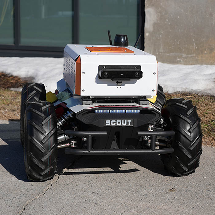
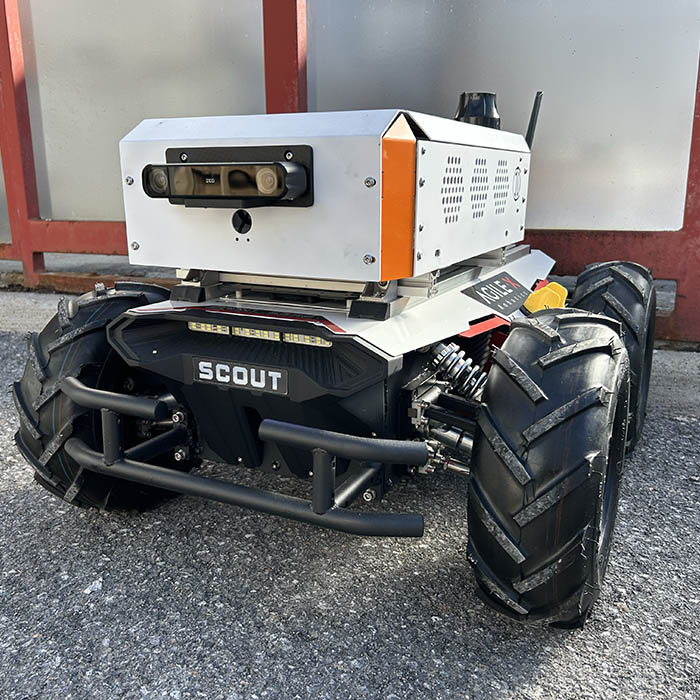
*Please note: The robot shown above is a close representation. See specifications below for included parts.
RESEARCH AREAS
Indoor/Outdoor Autonomous Navigation
Multi-environment SLAM and navigation
- Transition handling between GPS-based outdoor navigation and vision-based indoor navigation
- Localization in challenging GPS-denied environments
- GPS Waypoint Autonomy & Advanced Path Planning
- High-level mission planning using waypoint navigation
- Handling GPS inaccuracies (e.g., differential GPS, RTK corrections)
- Dynamic re-routing in the presence of obstacles
Mapping & Exploration
- Large-scale 3D mapping of indoor/outdoor environments
- Frontier-based exploration and environment coverage
- Multi-layered map representation (occupancy grids, elevation maps, semantic maps)
Robust Localization & Sensor Fusion
- Fusing LiDAR, depth camera, IMU, and GPS data for continuous localization
- State estimation under varied terrain (urban, rural, indoor floors)
- Resilient autonomy in the face of sensor dropouts
Long-Range Teleoperation & Remote Monitoring
- Teleoperation over 5G in semi-structured or unstructured outdoor sites
- Real-time data streaming for remote supervision or data collection
- Integration with cloud-based services for data logging and analytics
Safety & Redundancy Systems
- Fail-safe strategies when GPS or LiDAR fails
- Redundant sensor architectures
- Safe stop and emergency override research
specifications
This robotics integration includes AgileX Scout 2.0 (1), InDro Commander Autonomy (1), InDro Controller, InDro Teleoperation Package, InDro R&D Autonomy Package, InDro Outdoor Autonomy Package.
SPECIFICATIONS:
| AgileX Scout |
Dimensions: 930mm x 699mm x 349mm Weight: 68kg Differential Steering Max Speed: 1.5m/s Payload Capacity: 50kg 2.5h Run Time 3h Charge Time 30° Incline Climbing 135mm Ground Clearance 24V 30Ah Lithium Battery IP22 (IP44/IP64 Optional) |
| InDro Commander |
Dimensions: 61x41x21cm Weight: 6.5kg Aluminum shell DIN rail mounting IP54 100 TOPS computing power WiFi, 5G (eSIM) Ubuntu 22.04 ROS2 Humble 2TB storage 2x USB3.0 Type-A 1x HDMI Display 1x WAN RJ-45 GbE 3x LAN RJ-45 GbE 1x XT30-M 24V Power Input 1x XT30-F 12V 10A Power Output 1x XT30-F 5V 10A Power Output 1x Nano-SIM Slot |
| Robosense FAIRY LiDAR |
Mid-Range Digital LiDAR (VCSEL+SPAD-SoC) Up to 96 Channels (48-Beam Available) Range: 150m (80m @10% Reflectivity) FOV: 360° x 32° Point Rate: 1.37M pts/s Accuracy: ±0.5cm Angular Resolution: 0.25° x 0.33° Dimensions: Φ75mm x 70mm Weight: <350g Ethernet |
| Stereolabs ZEDX Camera |
Stereo Depth Camera Dual 1920×1200 Global Shutter Color Sensors Depth Range: 0.3-20m FOV: 110° (2mm Lens) / 75° (4mm Lens) GMSL2 Output (up to 15m to NVIDIA Jetson Orin) 16-bit IMU (Accelerometer + Gyroscope) External Frame Sync (100µs) Lens: 2mm or 4mm Neural Depth Engine IP67 Aluminum Enclosure Requires GMSL2 Capture Card / ZED Box |
| Vision-RTK 2 |
RTK VIO/GNSS/INS xFusion Deep Sensor Fusion (VIO + GNSS + IMU + Wheelspeed) 2x Multi-Band RTK GNSS Receivers (GPS / Galileo / BeiDou / GLONASS) Visual Odometry Centimeter-Level RTK Positioning Position Drift in GNSS Outage: 0.75% of Distance Max Velocity: 22m/s (Fusion) / 500m/s (GNSS) Dual-Antenna Instantaneous Heading Ethernet / Wi-Fi / Web GUI / ROS / NMEA |